This story has been on the news the last few days, and it concerns “issues” over satnav devices giving “wrong directions”.
The story is heavy on the usual media overkill. The vast majority of cases involving satnavs giving “wrong directions” are down to people being too stupid for words. The big question is not what to do with their satnav software, but whether these people should be allowed on the roads in the first place.
You’ll get lorry drivers going down roads that are too narrow for their vehicles – even though it is a perfectly legal route, and absolutely fine for anyone else. Or you’ll get people taking “the next turn right” and ending up on canal tow paths or railway lines because they’re simply too thick to recognise the difference between a road and… well, NOT a road.
Even the examples of ambulances “teetering on 100ft cliffs” would require a lot more information before I would concede the satnav was to blame. Even big-nuts emergency  service drivers possessing all the relevant anorak certificates are capable of judgement errors in the heat of the moment.
But it isn’t specifically the satnavs which are at fault. Even if the driver were following a printed road atlas mistakes could be made.
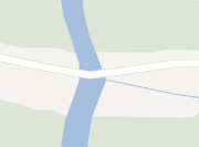
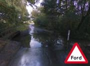
The road shown on the left, and clipped at high zoom from Google Maps, shows nothing unusual. However, in reality where it crosses that stream (which looks like a lake on the map), there is a FORD. The corresponding Google image on the right shows this  clearly. I take my pupils there sometimes… but not when it’s been raining, because then it COULD be as big as a lake (and often is)!
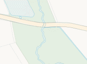
It’s only when you look at a genuine Ordnance Survey map (this one below is copied from their online resource) that there is any hint of there being anything unusual there – and even then you’ve got to be observant enough to note that the stream appears across the road and not under it. You’d need one of those huge fold-out hiking maps to get this sort of detail, but then a simple ½ mile trip to the shops would straddle three of them!
Most modern road atlases are NOT Ordnance Survey standard and this sort of information simply isn’t detailed – and even when it is you need a magnifying glass to e ven get close to being able to identify features like this from the style of print.
There was a time when good road atlases had features like this lettered with “FORD” in tiny writing, but many such crossings have disappeared – and I suppose it saves money omitting those that remain.
It isn’t the satnavs, but the maps which are deficient – if you can call it “deficient” not to identify every tiny feature. And even then, they’re only deficient if those using them are also lacking in common sense.
My point is that even when the information is present, it is so insignificant as to be easily missed. This ford is just one example, but almost all cases of lorries getting stuck in narrow lanes, or under low bridges; and of people trying to drive up sheer cliff faces only to discover they can’t are down to stupidity (and poor road skills) on one hand, and the difficulty in providing sufficient detail to cater for such stupidity on the other.
Are satnavs going to have to now contain data on gradients? Or warnings for every single river that might have a tow path entryway near it? Or perhaps audible alerts to identify field gateways and farm driveways for the benefit of the peripatetic pillocks passing by?
It would appear that the Transport Minister thinks so.
