 I originally wrote this back in 2012, but it has had a run of hits lately so I thought I’d update it.
Although the official line suggests otherwise, I’m sure these signs were around long before I became a driving instructor, and their exact purpose was always a bit of a mystery to me.
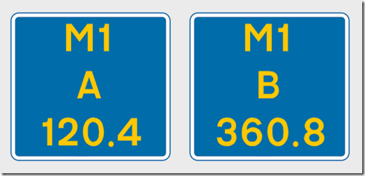
You’ve probably seen them. You get them mainly on motorways and they consist of a rectangular sign with yellow writing. There is the name of the motorway, a letter (A, B, J, K, L, or M), and a number. On the M1, for example, if you’re heading one way the letter will be ‘B’, whereas heading the other way it will be ‘A’. The numbers change by 0.5 between each sign.
I had guessed that they had something to do with being able to pinpoint precise locations, and that the signs were 500m apart so the number therefore represented a distance in kilometres. I hadn’t seen them explained anywhere, but it wasn’t until I started teaching people to drive – especially on Pass Plus motorway lessons – that I bothered to find out more. The trigger was a pupil who knew someone who was a paramedic, and who had been told that these signs “marked the distance to the end of the hard shoulder”.
That explanation didn’t make any sense. It was obviously wrong, since the signs appear even when there is no hard shoulder, and the numbers had no connection whatsoever with the end of it when there was.
Part of the difficulty in finding out what they were for was not knowing what they were called. They don’t appear in the current Highway Code, and Googling for “signs with yellow writing on motorways” or something similar didn’t help (certainly not at the time I became interested , anyway). I emailed the local Police traffic department and that was where I discovered they were called Driver Location Signs.
It turns out that they are “new signs on motorways” as of 2008. That still bugs me, because I’m damned sure they’ve been around longer than that, but maybe I’m imagining it. The Highways Agency has confirmed to me that they were “trialled as early as 2003”, but my memory says they were around even in the 90s. But that doesn’t matter.
Wikipedia covers them in more detail. The AA in slightly less detail. And this one is probably the most detailed.
They consist of three lines of text. The top line is the route name (e.g. M1, M6, M25, etc.). The second line is the carriageway identifier, A or B, and in spite of what The AA says they’re not necessarily London-centric (i.e. just think in terms of ‘A’ being the carriageway going in one direction, and ‘B’ the opposite carriageway going the other). If there are parallel but physically separated carriageways, those running with A are labelled ‘C’, and those running with B are labelled ‘D’. The letter ‘J’ denotes a slip road OFF carriageway A, and ‘K’ a slip road ON TO it. The letter ‘L’ is the slip road OFF carriageway B, and ‘M’ is the slip road ON TO it. Other letters can apparently be used at complex junctions. Finally, the third line shows the distance in kilometres from a known point (usually the start of the road), and is called “the chainage”.
The signs can only be a maximum distance of 500m apart, which is what they normally are, but if there is an obstruction they can be 400m or 300m apart (this explains why they don’t all end in 0.5 km). And they CAN be seen on some newer and very long dual carriageways. There’s a lot more to their placement, but this is a basic summary.
The AA likes to have them quoted when people report breakdowns. I have always assumed that they’re most useful to the emergency services.
There is a Highways Agency leaflet which explains them in simple terms, available to download from here.
Knowing what they are and how they work – and being able to explain it – is going to be important when we are eventually allowed to take learners on to motorways (in 2018, if that comes to pass).